Kaarten en gidsen > Kaarten & plattegronden > Landkaarten en wegenkaarten > Noord-Amerika > Canada > West-Canada > Canadese Rocky Mountains > Southwest Alberta, Southeast British Columbia
Southwest Alberta, Southeast British Columbia
1:500.000


€14,95
direct leverbaar!
- Zeer ruim assortiment
- Verzending 1-2 werkdagen
- Niet tevreden, geld terug
- Ruilen binnen 14 dagen
Titelinformatie
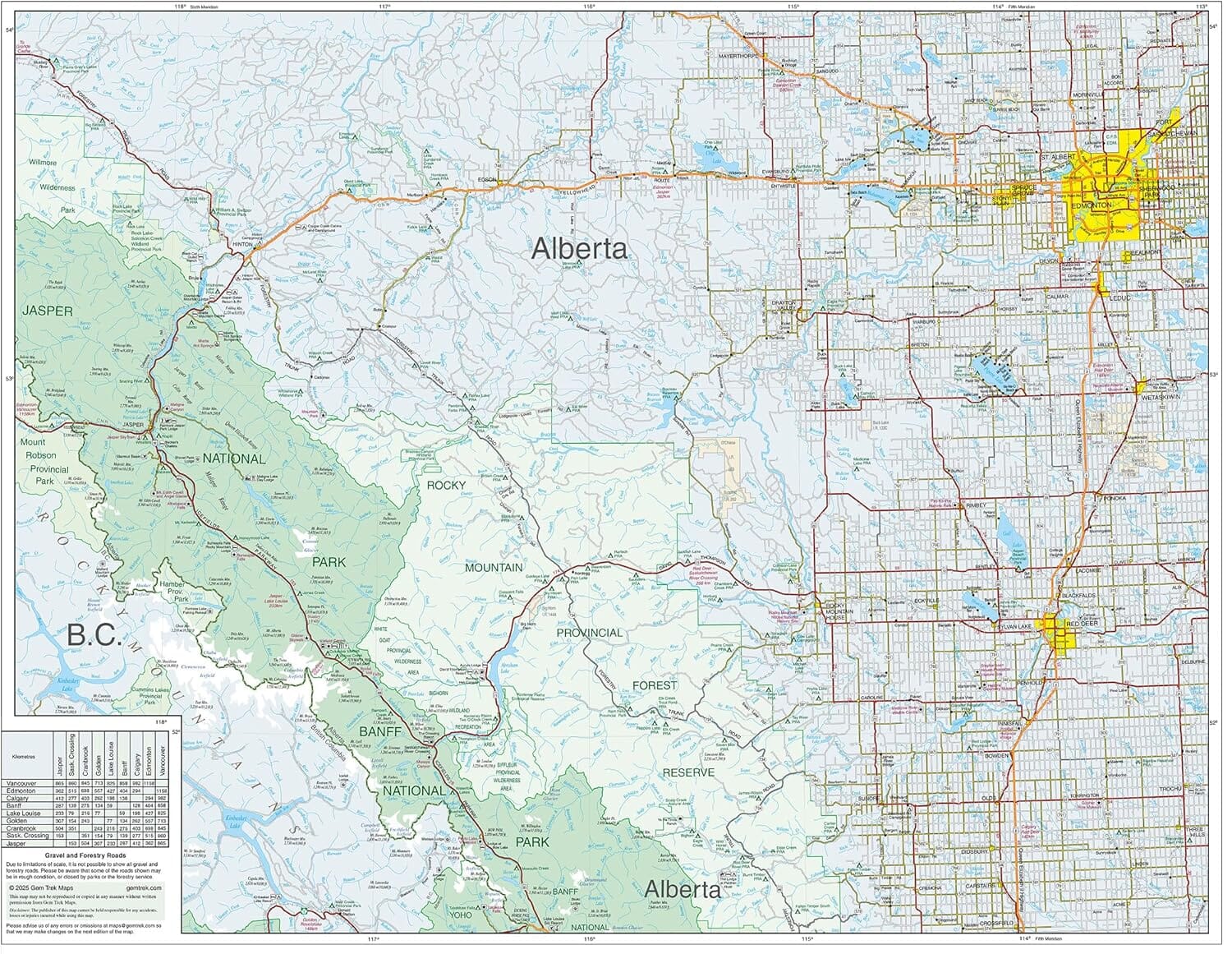
Fijn getekende kaart; hoogtelijnen en schaduwing zorgen voor een realistisch beeld van het reliëf. Daarnaast symbolen voor overnachtingslocaties, plus natuurlijk het complete wegennet.
The sixth edition of this popular 1:500,000-scale map covers Edmonton and Calgary, south to the U.S. border, and west as far as Jasper National Park in the north and Castlegar, in the B.C. Kootenays, in the south.
All the major highways are shown, as well as national and provincial parks and wilderness areas. The map also shows lesser-known back roads, and pinpoints the location of lodges, campgrounds and hot springs. Mileage charts on the front and back provide distances between major towns and cities.
Titelspecificaties
| Regio | Canadese Rocky Mountains |
|---|---|
| Uitgavedatum | Juni 2025 |
| Uitgever | |
| Serie | |
| ISBN | 9781990161216 |
| Categorie | Landkaarten en wegenkaarten |
Andere producten uit dezelfde regio
Van dezelfde regio verkrijgbaar
-
 Canmore / Kananaskis village 1:50.000Van de uitgever: Gem Trek's CANMORE & KANANASKIS VILLAGE MAP is designed for outdoor enthusiasts loodirect leverbaar!€15,95 > alles van Noord-Amerika
 -
 Best of Jasper 1:35.000 Explorer MapFijn getekende kaart; hoogtelijnen en schaduwing zorgen voor een realistisch beeld van het reliëf.direct leverbaar!€13,95 > alles van Noord-Amerika
 -
 Popular Day Hikes Canadian RockiesFeaturing a fresh design and the most current route updates, Popular Day Hikes is a series of bestsedirect leverbaar!€22,50 > alles van Noord-Amerika
 -
 SW British Columbia + Northern WashingtonFijn getekende kaart; hoogtelijnen en schaduwing zorgen voor een realistisch beeld van het reliëf.direct leverbaar!€9,95 > alles van Noord-Amerika
 -
 Jasper + Maligne Lake 1:100.000Fijn getekende kaart; hoogtelijnen en schaduwing zorgen voor een realistisch beeld van het reliëf.direct leverbaar!€17,90 > alles van Noord-Amerika
 -
 TI900 Banff South 1:100.000Mooie gedetailleerde kaart. Scheur- en watervast. Intekening van vele campsites en trails. | Nationadirect leverbaar!€16,95 > alles van Noord-Amerika
 -
 TI901 Banff North 1:100.000Mooie gedetailleerde kaart. Scheur- en watervast. Intekening van vele campsites en trails. | Nationadirect leverbaar!€16,95 > alles van Noord-Amerika
 -
 ITM Banff and Jasper National Parks | landkaart, autokaart 1:240.000 / 250.000Mooie gedetailleerde overzichtskaart (tweezijdig bedrukt) van de twee beroemdste Nationale Parken vadirect leverbaar!€15,95 > alles van Noord-Amerika
 -
 Banff + Mt.Assiniboine 1:100.000Fijn getekende kaart; hoogtelijnen en schaduwing zorgen voor een realistisch beeld van het reliëf.direct leverbaar!€17,95 > alles van Noord-Amerika
 -
 Moon Travel Guide Banff National Park | reisgidsMoon Banff National Park shows travelers the best way to experience all Banff has to offer—from sadirect leverbaar!€15,90 > alles van Noord-Amerika
 -
 Lonely Planet British ColumbiaGoede gidsen voor trekkers. Na info over land en volk, en reisvoorbereidingen volgen beschrijvingendirect leverbaar!€25,95 > alles van Noord-Amerika
 -
 TI903 Jasper North 1:100.000Mooie gedetailleerde kaart. Scheur- en watervast. Intekening van vele campsites en trails. | Nationadirect leverbaar!€14,95 > alles van Noord-Amerika