Upper & Lower Mustang 1:90.000
With detail route to Damodar Kunda & North of Lo-Manthang


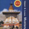
€26,90
niet direct leverbaar
mail ons voor de levertermijn
- Zeer ruim assortiment
- Verzending 1-2 werkdagen
- Niet tevreden, geld terug
- Ruilen binnen 14 dagen
Titelinformatie
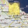
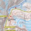
This is a detailed 1:90,000 scale map of Upper and Lower Mustang, the Forbidden Kingdom. The map shows trekking routes in the northern part of the Annapurna Conservation Area, from Jomosom and Muktinath to Lo-Manthang, and further north to the Kora La pass on the Tibetan border. Also shown are several spurs eastwards, including the Mustag - Phu trek and the Damodar Kunda trek.
About the Nepa Maps / Himalayan MapHouse 500 Series Trekking Maps
The overprint highlights main trekking routes and numerous local trails, with symbols indicating various places of interest and tourist facilities. Most maps are indexed (places, base camps, peaks, lakes and passes) and include additional information such as route profiles, glossaries, etc.
Titles in this series have cartography is based on the country's topographic survey, with contours usually at 40m or 50m intervals, enhanced by relief shading, colouring and graphics to show various features of the terrain, including glaciers, forested or cultivated areas, etc. Numerous peaks, with additional spot heights, plus names of glaciers and mountain ranges are prominently shown. The network of rivers, streams and lakes is shown in detail, with many smaller rivers and lakes named.
All the information is in English and heights are given in metres.
Titelspecificaties
| Regio | Nepal |
|---|---|
| Uitgavedatum | September 2019 |
| Uitgever | |
| Serie | |
| ISBN | 9789993323952 |
| Categorie | Wandelkaarten |


-
 Rough Guide Nepal *Uitgebreide en goed gedocumenteerde reisinformatie over Nepal. Achtergrondhoofdstukken over maatschadirect leverbaar!€9,90 > alles van Azië
 -
 Everest Base Camp adventure map 1:50.000Mooie gedetailleerde kaart, voorzien van veel extra info en gedrukt op water- en scheurvast materiaadirect leverbaar!€17,95 > alles van Azië
 -
 Nepal: nieuwe wegen in de HimalayaNepal. De Himalaya. Mount Everest. Kathmandu. Namen die een exotische droomwereld oproepen. Maar beaniet direct leverbaar€19,50 > alles van Azië
 -
 Chamlang | Myra de RooyInspirerend en spannend reis- en klimavontuurover zes Nederlandse vrouwen die, zonder hulp van anderdirect leverbaar!€30,95 > alles van Azië
 -
 Zonder de top te bereiken | Paolo CognettiWaar zijn we naar op zoek wanneer we op reis gaan? Deze vraag staat centraal in Zonder de top te berdirect leverbaar!€17,95 > alles van Azië
 -
 LMN 3 Kanjiroba East, Huinchuli, TibrikotThese maps typically lack contour lines, but show ridge lines and peaks with yellow lines. Numerousdirect leverbaar!€7,90 > alles van Azië
 -
 In de Schaduw van de Berg | Silvia Vasquez-LavadoIn de schaduw van de berg van Silvia Vasquez-Lavado is een nagelbijtend spannende memoir over je gredirect leverbaar!€23,95 > alles van Azië
 -
 Manaslu Base Camp NS 521 | wandelkaart 1:60.000A detailed 1:60,000 map fo the region around Makalu basecamp. The map covers a large ranges of hieghdirect leverbaar!€26,90 > alles van Azië
 -
 Island Peak / Mera Peak 1:25.000Topographic climbing maps from Island & Mera Peak 1:25'000, village maps of Lukla and Namche Bazar,direct leverbaar!€22,90 > alles van Azië
 -
 9789993323044 Himalayan MapHouse Wandelkaarten Nepal Wandelkaarten Nepal") Pisang Peak 1:50.000 (Annapurna Region)Mooie, gedetailleerde kaart met trekking routes (deel van de Annapurna Route) en klimroutes. Symboledirect leverbaar!€26,50 > alles van Azië
Pisang Peak 1:50.000 (Annapurna Region)Mooie, gedetailleerde kaart met trekking routes (deel van de Annapurna Route) en klimroutes. Symboledirect leverbaar!€26,50 > alles van Azië -
 wandelgids Annapurna Treks Rother WanderführerDie Autoren Susanne Kauper und Stephan Baur haben die Touren so ausgewählt, dass für jeden Geschmadirect leverbaar!€21,90 > alles van Azië
 -
 Spitfire over Everest | Kenneth NeameThis is an outstanding story of coincidence, quick wit, skill,routine, improvisation and seized opponiet direct leverbaar€36,50 > alles van Azië