Kaarten en gidsen > Kaarten & plattegronden > Landkaarten en wegenkaarten > Australië, Nieuw Zeeland, Zuid-Pacifische Oceaan > Pacifische Oceaan (Pacific) > ITM South Pacific Cruising / Samoa 1:12.000.000
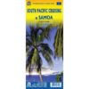
ITM South Pacific Cruising / Samoa 1:12.000.000
")
")
")
€13,95
direct leverbaar!
- Zeer ruim assortiment
- Verzending 1-2 werkdagen
- Niet tevreden, geld terug
- Ruilen binnen 14 dagen
Titelinformatie
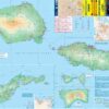
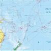
Fraaie, relatief gedetailleerde overzichtskaart. Veel kaarten uit deze serie hebben op de achterkant plattegronden van de belangrijkste plaatsen, in dit geval een uitgebreide kaart van Seoul. ITM geeft onder andere veel kaarten uit van landen en gebieden die door andere uitgevers nogal eens over het hoofd worden gezien. In rode tekst staat op de kaart - daar waar van toepassing - vaak enige toeristische informatie. | This is a new venture for ITMB. Cruising is a rapidly-growing segment of the travel industry. In conjunction with several cruise ship lines, ITM have prepared a map of the South Pacific Ocean, which extends southwards from Hawai'i to the southern tip of New Zealand and eastwards from central Australia/Papua New Guinea to the Pitcairn Islands. Thus, it does not include the popular South East Asia and China coast routes.The map of the South Pacific region fills one side of the map. Most of the area covered in the map is water, with island countries such as Fiji, Tonga, Kiribati, Tahiti, and the Cook Islands being visible, but without details. The cruise routes are shown with red dashed lines. The ocean area includes hill shading for the deep trenches of the Pacific Ocean. By doing so, the blue of the water areas is softened by the grey of deep trenches. The reverse side of the map covers the two entities known collectively as Samoa: Samoa (or Western Samoa) and American Samoa. The two main islands and two small islands are presented at 1:160,000 scale. An inset map of the capital, Apia is included. Map opens out to 1000mm x 680mm, printed on both sides
Titelspecificaties
| Regio | Pacifische Oceaan (Pacific) |
|---|---|
| Uitgavedatum | 2020 |
| Uitgever | |
| ISBN | 9781771297189 |
| Categorie | Landkaarten en wegenkaarten |
Andere producten uit dezelfde regio
Van dezelfde regio verkrijgbaar
-
") Lonely Planet Tahiti + French PolynesiaGoede gidsen voor trekkers. Na info over land en volk, en reisvoorbereidingen volgen beschrijvingendirect leverbaar!€24,95 > alles van Australië, Nieuw Zeeland, Zuid-Pacifische Oceaan
Lonely Planet Tahiti + French PolynesiaGoede gidsen voor trekkers. Na info over land en volk, en reisvoorbereidingen volgen beschrijvingendirect leverbaar!€24,95 > alles van Australië, Nieuw Zeeland, Zuid-Pacifische Oceaan -
") New Caledonia / Nouvelle Caledonie 1:500.000Mooie overzichts-/ wegenkaart, uitgegeven door de Franse topografische dienst.niet direct leverbaar€11,90 > alles van Australië, Nieuw Zeeland, Zuid-Pacifische Oceaan
New Caledonia / Nouvelle Caledonie 1:500.000Mooie overzichts-/ wegenkaart, uitgegeven door de Franse topografische dienst.niet direct leverbaar€11,90 > alles van Australië, Nieuw Zeeland, Zuid-Pacifische Oceaan -
") ITM Fiji & Tonga | landkaart, autokaart 1:555.000Fraaie, relatief gedetailleerde overzichtskaart. Veel kaarten uit deze serie hebben op de achterkantdirect leverbaar!€13,95 > alles van Australië, Nieuw Zeeland, Zuid-Pacifische Oceaan
ITM Fiji & Tonga | landkaart, autokaart 1:555.000Fraaie, relatief gedetailleerde overzichtskaart. Veel kaarten uit deze serie hebben op de achterkantdirect leverbaar!€13,95 > alles van Australië, Nieuw Zeeland, Zuid-Pacifische Oceaan -
") Lost Paradiseet on the island made famous by "Mutiny on the Bounty, "the true account of belated justice in an isdirect leverbaar!€26,95 > alles van Australië, Nieuw Zeeland, Zuid-Pacifische Oceaan
Lost Paradiseet on the island made famous by "Mutiny on the Bounty, "the true account of belated justice in an isdirect leverbaar!€26,95 > alles van Australië, Nieuw Zeeland, Zuid-Pacifische Oceaan -
") Lonely Planet FijiGoede gidsen voor trekkers. Na info over land en volk, en reisvoorbereidingen volgen beschrijvingendirect leverbaar!€23,95 > alles van Australië, Nieuw Zeeland, Zuid-Pacifische Oceaan
Lonely Planet FijiGoede gidsen voor trekkers. Na info over land en volk, en reisvoorbereidingen volgen beschrijvingendirect leverbaar!€23,95 > alles van Australië, Nieuw Zeeland, Zuid-Pacifische Oceaan -
") Pidgin Lonely Planet phrasebookThe best available guide to the pidgins and creoles of Papua New Guinea, Solomon Islands, Vanuatu, Ndirect leverbaar!€7,95 > alles van Australië, Nieuw Zeeland, Zuid-Pacifische Oceaan
Pidgin Lonely Planet phrasebookThe best available guide to the pidgins and creoles of Papua New Guinea, Solomon Islands, Vanuatu, Ndirect leverbaar!€7,95 > alles van Australië, Nieuw Zeeland, Zuid-Pacifische Oceaan -
 ITM New Caledonia & Oceania Cruises | landkaart, overzichtskaart 1:12.000.000 / 530,000Side 1 features a map of New Caledonia (main island and Loyalty Islands). Side 2 covers the South Paniet direct leverbaar€13,95 > alles van Australië, Nieuw Zeeland, Zuid-Pacifische Oceaan
 -
") South Pacific | fotoboekThe natural beauties of Oceania's island world, scattered far across the South Pacific and divided iniet direct leverbaar€47,50 > alles van Australië, Nieuw Zeeland, Zuid-Pacifische Oceaan
South Pacific | fotoboekThe natural beauties of Oceania's island world, scattered far across the South Pacific and divided iniet direct leverbaar€47,50 > alles van Australië, Nieuw Zeeland, Zuid-Pacifische Oceaan -
") South Pacific overzichtskaart 1:10.000.000Mooie overzichtskaart met arcering, secundaire kaarten, stadsplattegronden, toeristische attracties,niet direct leverbaar€14,95 > alles van Australië, Nieuw Zeeland, Zuid-Pacifische Oceaan
South Pacific overzichtskaart 1:10.000.000Mooie overzichtskaart met arcering, secundaire kaarten, stadsplattegronden, toeristische attracties,niet direct leverbaar€14,95 > alles van Australië, Nieuw Zeeland, Zuid-Pacifische Oceaan -
") Arts des Mers du SudMooi, uitgebreid boek met belangrijke iconografie in kleur en in zwart-wit. Een aantal illustratiesdirect leverbaar!€12,90 > alles van Azië
Arts des Mers du SudMooi, uitgebreid boek met belangrijke iconografie in kleur en in zwart-wit. Een aantal illustratiesdirect leverbaar!€12,90 > alles van Azië -
") ITM Tahiti Polynesian Cruising | landkaart, autokaart 1:100.000Een fraaie gedetailleerde overzichtskaart van Tahiti en de Cookeilanden. Bevat aanduidingen van o.adirect leverbaar!€13,95 > alles van Australië, Nieuw Zeeland, Zuid-Pacifische Oceaan
ITM Tahiti Polynesian Cruising | landkaart, autokaart 1:100.000Een fraaie gedetailleerde overzichtskaart van Tahiti en de Cookeilanden. Bevat aanduidingen van o.adirect leverbaar!€13,95 > alles van Australië, Nieuw Zeeland, Zuid-Pacifische Oceaan -
") Palau 1:170.000 / 105.000 Guide & Dive MapThis is a guide to the undisputed best diving place in the world.If you wish to plan an expedition odirect leverbaar!€11,50 > alles van Australië, Nieuw Zeeland, Zuid-Pacifische Oceaan
Palau 1:170.000 / 105.000 Guide & Dive MapThis is a guide to the undisputed best diving place in the world.If you wish to plan an expedition odirect leverbaar!€11,50 > alles van Australië, Nieuw Zeeland, Zuid-Pacifische Oceaan