Kaarten en gidsen > Wandelen > Wandeltochten > Meerdaagse wandelroutes > Europa > Britse Eilanden > Groot-Brittannië > Wales > Offa's Dyke Path
Offa's Dyke Path


€21,95
direct leverbaar!
- Zeer ruim assortiment
- Verzending 1-2 werkdagen
- Niet tevreden, geld terug
- Ruilen binnen 14 dagen
Titelinformatie
Offa's Dyke Path: Prestatyn to Chepstow
- 98 maps
- 32 colour pages including 3pp colour flower guide
- 120mm x 180mm, 5" x7"
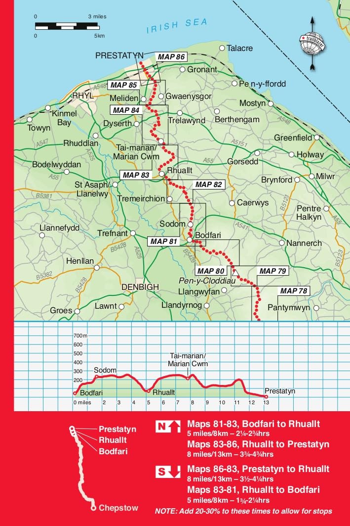
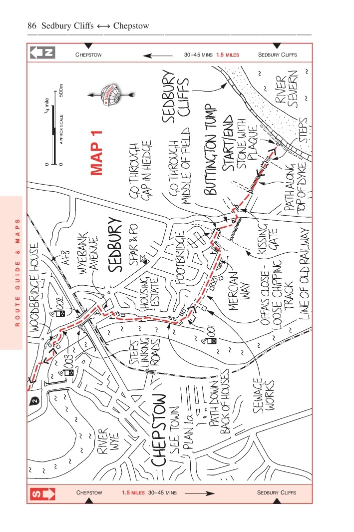
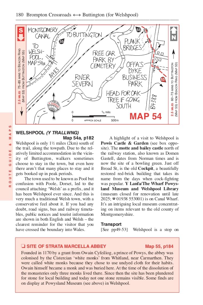
The Offa's Dyke Path is a superb National Trail that runs from the North Wales coast to the Severn Estuary following the line of Offa's Dyke, an impressive 8th-century earthwork along the English/Welsh border. The ever-changing landscape - the Clwydian Range, the Shropshire Hills, the Black Mountains and the Wye Valley - is steeped in history and legend providing 177 miles (285km) of fascinating walking.
- Includes 98 detailed walking maps
- Unique mapping features
- Itineraries for all walkers
- Detailed public transport information for all access points.
- Practical information for all budgets
Downloadable GPS points now included.
Titelspecificaties
| Regio | Wales |
|---|---|
| Uitgavedatum | Oktober 2025 |
| Taal | Engels |
| Gewicht | 0,27 kg |
| Uitgever | |
| Serie | |
| ISBN | 9781912716425 |
| Pagina aantal | 268 |
| Formaat | 12 x 18 cm |
| Categorie | Meerdaagse wandelroutes, Wandelgidsen |
Van dezelfde regio verkrijgbaar
-
 LR-171 Cardiff, Newport, Pontypool | topografische wandelkaartKLIK OP DE SERIENAAM, DAN VERSCHIJNEN ALLE KAARTEN OP VOLGORDE | Deel uit de serie topografische kaaniet direct leverbaar€19,95 > alles van Europa
 -
 LR-145 Cardigan, Mynydd Preseli | topografische wandelkaartKLIK OP DE SERIENAAM, DAN VERSCHIJNEN ALLE KAARTEN OP VOLGORDE | Deel uit de serie topografische kaaniet direct leverbaar€19,95 > alles van Europa
 -
 9781839811906 Vertebrate Publishing Fietsgidsen Wales") Bikepacking Wales | fietsgids (voor mountainbikers)Bikepacking Wales by Emma Kingston contains 18 great multi-day mountain bike adventures. For such adirect leverbaar!€27,95 > alles van Europa
Bikepacking Wales | fietsgids (voor mountainbikers)Bikepacking Wales by Emma Kingston contains 18 great multi-day mountain bike adventures. For such adirect leverbaar!€27,95 > alles van Europa -
 wandelgids Snowdonia Slate Trail, kaartenatlasjeLichtgewicht wandelgids op A5 formaat, die vooral veel kaartenmateriaal bevat over deze route. Aangedirect leverbaar!€22,50 > alles van Europa
 -
 EXP-035 North Pembrokeshire OL35 | wandelkaart 1:25.000Deel uit een serie zeer gedetailleerde topografische kaarten (1:25.000), perfect om mee te wandelen.direct leverbaar!€19,95 > alles van Europa
 -
 The Pocket Rough Guide to PembrokeshireDiscover the best of Pembrokeshire with this compact, practical, entertaining Pocket Rough Guide witdirect leverbaar!€13,50 > alles van Europa
 -
 NN04 The Celtic TrailThe official route map for the Celtic Trail network on National Route 4 in South and West Wales fromdirect leverbaar!€13,50 > alles van Europa
 -
 EXP-214 Llanidloes / Newtown / Y Drenewydd | wandelkaart 1:25.000Deel uit een serie zeer gedetailleerde topografische kaarten (1:25.000), perfect om mee te wandelen.niet direct leverbaar€19,95 > alles van Europa
 -
 wandelgids Snowdonia NorthEngelstalige gids in handig vestzakformaat. Bevat gedetailleerde routebeschrijvingen, veel praktischdirect leverbaar!€18,50 > alles van Europa
 -
 Snowdonia North Mountain Map | wandelkaart 1:40.000Perfecte kaart, met wandelroutes. Een deel op 1:25.000. Scheur- en watervast. *** Titel maakt deeldirect leverbaar!€29,95 > alles van Europa
 -
 Noord-Engeland, Wales | Michelin reisgidsDe serie Groene Reisgidsen van Michelin is een beproefde en betrouwbare reisgidsenreeks. Of u nu lekdirect leverbaar!€27,95 > alles van Europa
 -
 LR-116 Denbigh + Colwyn Bay | topografische wandelkaartKLIK OP DE SERIENAAM, DAN VERSCHIJNEN ALLE KAARTEN OP VOLGORDE | Deel uit de serie topografische kaadirect leverbaar!€19,95 > alles van Europa