NP108 Mustang 1:100.000 GHT trekking map
Lo Monthang – Teri La – Damodar Himal (weather-proof)


€29,50
direct leverbaar!
- Zeer ruim assortiment
- Verzending 1-2 werkdagen
- Niet tevreden, geld terug
- Ruilen binnen 14 dagen
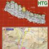
Upper Mustang area at 1:100,000 in the Nepa Maps series which provides extensive coverage of trekking areas of Nepal on detailed contoured maps with trekking routes and hiking trails, huts and camp sites, local places of interest and other tourist information.
This map covers the upper Mustang area at a 1:100,000 scale, offering trekking routes in the northern part of the Annapurna Conservation Area, from Jomosom and Muktinath to Lo-Manthang, and further north to the Kora La pass on the Tibetan border. Also shown are several spurs eastwards, including the Mustag - Phu trek and the Damodar Kunda trek. Additional information includes a plan of the Walled City of Lo-Manthang, a profile of the route, plus tables showing the route in stages with altitudes in metres and feet and trekking times. Contours are at 40m intervals.
About the Nepa Maps / Himalayan MapHouse 500 Series Trekking Maps
The overprint highlights main trekking routes and numerous local trails, with symbols indicating various places of interest and tourist facilities. Most maps are indexed (places, base camps, peaks, lakes and passes) and include additional information such as route profiles, glossaries, etc.
Titles in this series have cartography is based on the country's topographic survey, with contours usually at 40m or 50m intervals, enhanced by relief shading, colouring and graphics to show various features of the terrain, including glaciers, forested or cultivated areas, etc. Numerous peaks, with additional spot heights, plus names of glaciers and mountain ranges are prominently shown. The network of rivers, streams and lakes is shown in detail, with many smaller rivers and lakes named.
All the information is in English and heights are given in metres.


-
 Everest 1922 | Mick ConefreyThough it remains by far the world's most famous mountain, in recent years Everest's reputation hasdirect leverbaar!€29,95 > alles van Azië
 -
 Manaslu Base Camp NS 521 | wandelkaart 1:60.000A detailed 1:60,000 map fo the region around Makalu basecamp. The map covers a large ranges of hieghdirect leverbaar!€26,90 > alles van Azië
 -
 Everest | Sangma FrancisDit ongelooflijke mooie en prachtig geïllustreerde boek vertelt het verhaal van een magische plek,direct leverbaar!€20,00 > alles van Azië
 -
 Kangchenjunga Region 1:100,000 GHT trekking mapThe Great Himalaya Trail in Nepal has been split into 10 sections to reflect the diversity of landscdirect leverbaar!€29,50 > alles van Azië
 -
 N05 Great Himalayan Trail: Annapurna & MustangThis is one of a series of 10 maps covering the Great Himalayan Trail.Annapurna and Mustang area indirect leverbaar!€27,90 > alles van Azië
 -
 9783866861527 Conrad Stein Verlag Outdoor - Der Weg ist das Ziel Meerdaagse wandelroutes, Wandelgidsen Nepal") OD-152 Trekking durch Helambu, Gosainkund und Langtang | wandelgids (Duitstalig)Das Trekking in Helambu, Gosainkund und Langtang entführt Sie in eine Landschaft, die dem Everest odirect leverbaar!€15,90 > alles van Azië
OD-152 Trekking durch Helambu, Gosainkund und Langtang | wandelgids (Duitstalig)Das Trekking in Helambu, Gosainkund und Langtang entführt Sie in eine Landschaft, die dem Everest odirect leverbaar!€15,90 > alles van Azië -
 Pokhara Town + Valley 1:9.000/20.000/50.000Stadsplattegrond Pokhara, en omgevingskaartdirect leverbaar!€10,90 > alles van Azië
 -
 Khumbu 1:125.000A map of the Everest trekking region at a scale of 1:125,000 with contours at 100 meter intervals, pniet direct leverbaar€13,90 > alles van Azië
 -
 N07 Great Himalayan Trail: Langtang & HelambuThis is one of a series of 10 maps covering the Great Himalayan Trail.Langtang and Helambu region indirect leverbaar!€27,50 > alles van Azië
 -
 Mustang - Paradise foundThis unique pictorial book is the result of a long painstaking but productive collaboration betweenniet direct leverbaar€38,90 > alles van Azië
 -
 The StormsIn August 1979 twenty-seven-year-old Mike Trueman set sail from the south-west coast of Wales, en rodirect leverbaar!€19,90 > alles van Azië
 -
 Trotter NepalPraktische, lichtgewicht reisgidsen. Sober opgemaakt maar wel informatief. Vooral veel praktische vedirect leverbaar!€19,95 > alles van Azië